


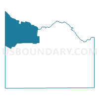
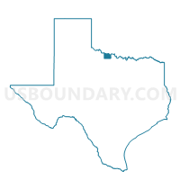
Voting District 0049, Wichita County, Texas
About
Outline

Summary
| Unique Area Identifier | 678153 |
| Name | Voting District 0049 |
| County | Wichita County |
| State | Texas |
| Area (square miles) | 88.00 |
| Land Area (square miles) | 87.91 |
| Water Area (square miles) | 0.08 |
| % of Land Area | 99.91 |
| % of Water Area | 0.09 |
| Latitude of the Internal Point | 34.11300520 |
| Longtitude of the Internal Point | -98.87214900 |
Maps

Graphs
Select a template below for downloading or customizing gragh for Voting District 0049, Wichita County, Texas


Neighbors
Neighoring Voting District (by Name) Neighboring Voting District on the Map
- Voting District 0020, Wilbarger County, TX
- Voting District 0024, Wichita County, TX
- Voting District 0025, Wichita County, TX
- Voting District 0032, Wichita County, TX
- Voting District 0048, Wichita County, TX
- Voting District 7, Tillman County, OK
- Voting District 9, Tillman County, OK
Top 10 Neighboring County Subdivision (by Population) Neighboring County Subdivision on the Map
- Burkburnett CCD, Wichita County, TX (11,496)
- Iowa Park CCD, Wichita County, TX (7,318)
- Electra CCD, Wichita County, TX (4,007)
- East Tillman CCD, Tillman County, OK (1,488)
- Davidson CCD, Tillman County, OK (491)
- Harrold-Oklaunion CCD, Wilbarger County, TX (463)
Top 10 Neighboring Place (by Population) Neighboring Place on the Map
Top 10 Neighboring Unified School District (by Population) Neighboring Unified School District on the Map
- Burkburnett Independent School District, TX (22,258)
- Iowa Park Consolidated Independent School District, TX (13,494)
- Electra Independent School District, TX (3,174)
- Grandfield Public Schools, OK (1,264)
- Davidson Public Schools, OK (455)
- Harrold Independent School District, TX (129)
Top 10 Neighboring State Legislative District Lower Chamber (by Population) Neighboring State Legislative District Lower Chamber on the Map
- State House District 69, TX (140,554)
- State House District 68, TX (135,942)
- State House District 63, OK (36,149)
Top 10 Neighboring State Legislative District Upper Chamber (by Population) Neighboring State Legislative District Upper Chamber on the Map
Top 10 Neighboring 111th Congressional District (by Population) Neighboring 111th Congressional District on the Map
Top 10 Neighboring Census Tract (by Population) Neighboring Census Tract on the Map
- Census Tract 138, Wichita County, TX (3,697)
- Census Tract 137, Wichita County, TX (2,785)
- Census Tract 9503, Wilbarger County, TX (1,849)
- Census Tract 705, Tillman County, OK (1,487)
- Census Tract 701, Tillman County, OK (1,219)
Top 10 Neighboring 5-Digit ZIP Code Tabulation Area (by Population) Neighboring 5-Digit ZIP Code Tabulation Area on the Map
- 76367, TX (13,045)
- 76354, TX (11,270)
- 76360, TX (3,502)
- 73546, OK (1,232)
- 73530, OK (442)
- 76364, TX (193)